


MaRando - GPS Randonnée
Опис програми MaRando - GPS Randonnée
Початківець або професіонал у піших прогулянках, MaRando — це програма GPS, яка вам потрібна.
MaRando GPS захищає ваші подорожі та пропонує вам більше, ніж просто GPS.
✪ СПОРТ ТА ПРАКТИКИ
піші прогулянки,
ходити,
гірський велосипед,
велосипед,
біг,
гірськолижний туризм,
рекет,
стежка,
полювання,
збір,
альпінізм,
скандинавська ходьба,
верхова їзда,
каяк,
навігація,
і багато іншого
✪ ОСНОВНІ ХАРАКТЕРИСТИКИ
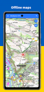
╰┈➤ НА ПОЛІ (офлайн)
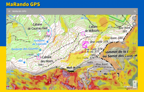
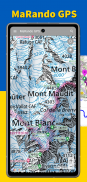
➢ Відображення географічних карт
➢ Відображення ваших персональних карток
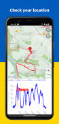
➢ Геолокація GPS на фоні карти
➢ Запис курсу
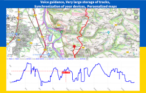
➢ Дотримуйтесь маршруту GPS
➢ Звукові або голосові підказки
➢ Аналіз своєї позиції
╰┈➤ НА ПОЛЕ (з мережею)
➢ Завантажте детальні топографічні карти:
IGN, SwissTopo, кадастр, нахил схилів, IGN Іспанія, топографічні карти, персоналізовані карти...
➢ Додавання власних карт шляхом додавання власних серверів мозаїчних зображень - WMTS - Raster -
(Приклад: карти IGN, див. https://data.geopf.fr/annexes/ressources/wfs/topographie.xml)
➢ Збереження вашої історії треків (більше 500 треків)
➢ Збереження ваших маршрутів
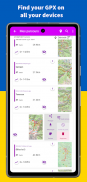
➢ Доступ і синхронізація ваших маршрутів на різних пристроях
➢ Імпорт треку GPX
➢ Обмін треками GPX вашого місцезнаходження
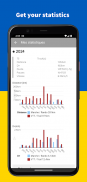
➢ Статистика ваших поїздок і виступів
✪ ВИКОРИСТАННЯ
➢ Щоб підготуватися до подорожі, ви можете заздалегідь завантажити обрані вами карти. Таким чином, коли ви будете далеко від будь-якої мережі, кошти на карті залишаться доступними.
➢ Усі треки, зроблені в полі або імпортовані, зберігаються у вашому пристрої. Ви можете зберігати дуже велику кількість, не порушуючи належне функціонування програми. Доступні численні критерії пошуку та сортування, такі як відстань маршруту, розташування, близькість до міста, назва маршруту тощо.
➢ Історія ваших маршрутів доступна на всіх ваших пристроях через ваш диск Google і гарантує збереження ваших маршрутів.
➢ Кожен із ваших маршрутів можна відновити та поділитися у файлі GPX.
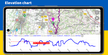
➢ Для кожного маршруту ви отримуєте профіль маршруту зі статистикою руху: перерви, позитивний або негативний перепад висот, середні швидкості (з перервами чи ні), тривалість зусиль, відстань тощо... Алгоритми обчислення надійні, щоб реагувати на реальність на землі.
➢ MaRando GPS пропонує доступ до маршрутів Utagawa, щоб імпортувати їх безпосередньо в додаток.
➢ MaRando GPS дозволяє додавати ваші персоналізовані карти з URL-адреси плиткового сервера.
➢ MaRando GPS під час запису вашої подорожі залишається дуже економним, оскільки запис може тривати більше одного дня.
➢ Під час просування ви можете переглядати профіль висоти на графіку та оцінювати: своє положення, факт, інше, що потрібно зробити, порівняти це з іншим маршрутом
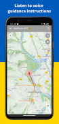
➢ З попередньо завантаженого маршруту та завдяки голосовому гіду ви можете прослуховувати вказівки напрямку, такі як «поверніть праворуч» або «20 метрів позаду», «на маршруті» тощо... Щоб уникнути надто великої кількості повідомлень, гід лише дає вам індикацію, якщо ви залишаєте курс або потрібно змінити напрямок.
➢ MaRando GPS пропонує відображення напрямку на карті, щоб визначити цільовий об’єкт, наприклад вершину чи місто.
➢ Доступна статистика вашої роботи за останній рік і місяці.
➢ Для вашої безпеки доступна надсилання вашого GPS-положення за допомогою SMS.
✪ ПОЧАТОК РОБОТИ ТА НАЛАШТУВАННЯ
➢ MaRando GPS був розроблений інтуїтивно зрозумілим, меню «Довідка» доступне, щоб допомогти вам. Відео також є для кращого розуміння.
➢ Доступно багато параметрів, конфігурація кожного з яких супроводжується пояснювальним описом.
✪ КОНТАКТ ТА ПОКРАЩЕННЯ
➢ Зверніться до support@ma-logiciel.com
MaRando - GPS Randonnée – Версія 4.25.20
(25-02-2025)MaRando - GPS Randonnée - інформація про APK
Версія APK: 4.25.20ID пакета: com.morillon.marandoОстання версія MaRando - GPS Randonnée
Інші версії


 3.64
3.64


Додатки в цій категорії

Вам також може сподобатися...


